ZIP code estimate · TX
ZIP Code 79106 Crime Map and Crime Rate
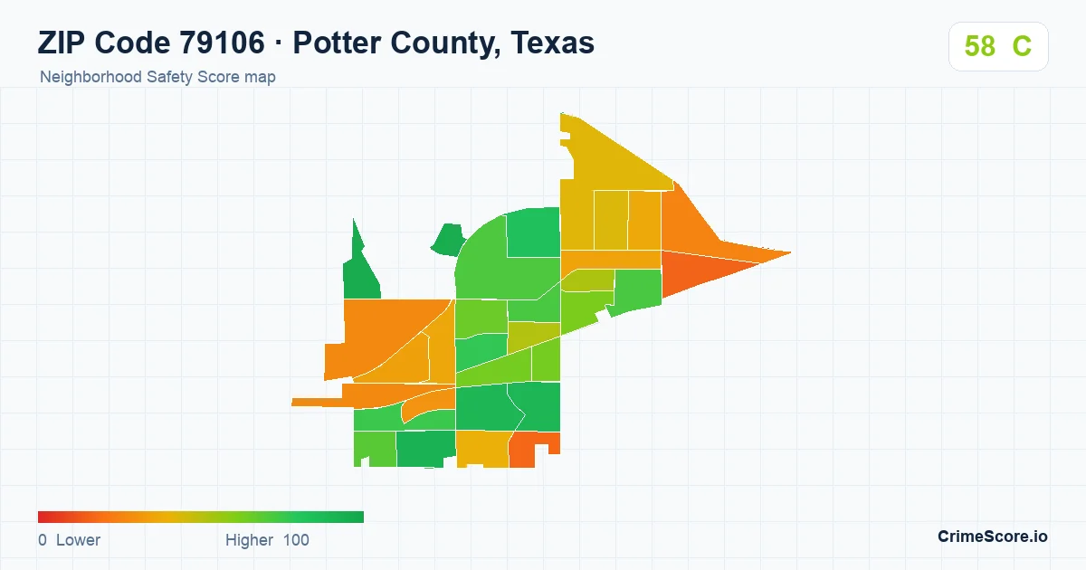
CrimeScore estimates ZIP Code 79106 in Potter County, Texas for the matching Census ZCTA, which contains 30 scored block groups. Use this page for broad area context. Exact latitude and longitude lookups remain more precise for property-level workflows.
Is ZIP Code 79106 safe?
ZIP Code 79106 has a Safety Score of 58 out of 100, grade C, higher than 49% of US ZIP codes. It is a modeled, comparative estimate for broad ZIP-area context, not a property-level crime rate or guarantee.
ZIP Code 79106 in Potter County, Texas is an area estimate based on the matching Census ZCTA, not an exact USPS delivery-route boundary. CrimeScore assigns it a C grade and a Safety Score of 58, which falls in the moderate modeled safety range.
The ZIP code estimate summarizes 30 scored Census block groups.
For broader surrounding context, compare the related Potter County map; ZIP code pages are best for area-level search, while county pages show wider local context.
For address-level workflows, use an exact latitude and longitude lookup in the API. Coordinate lookups can resolve to a specific Census block group instead of a broader ZIP code estimate.
Score export: August 16, 2026 · model 2.0.
- Scored local areasA count, not a coverage percentage
- 30
Score components
Compare the same component across locations; different components are not directly comparable.
- Violent crime
- 57/100
- Property crime
- 58/100
- Disorder
- 56/100
- Crime frequency
- 58/100
Modeled Safety Scores are not official crime rates or guarantees.
Compare local areas
ZIP 79106 and surrounding ZIP profiles
The 9 closest ZIP centers assigned to Potter County, ordered by straight-line distance from this ZIP’s center. These are area comparisons, not adjoining-boundary or travel-distance measurements; rural ZIP centers can be far apart.
Of these 9 surrounding ZIP estimates, 4 are lower than ZIP 79106, 5 are higher, and 0 have the same score.
Higher scores indicate safer modeled conditions. Scored areas are Census block groups, not a coverage percentage.
Compare all ZIP profiles assigned to Potter County
The county page shows the wider range of ZIP estimates. Its headline county score uses a separate national ranking and is not an average of ZIP scores.
From our ZIP variation study · July 14, 2026
How local scores varied within ZIP 79106
In this research snapshot, the 10th–90th percentile range across 30 intersecting block groups was 26.8–89.2. The full range was 16–95.
- Lowest
- 16
- 10th percentile
- 26.8
- Median
- 62.5
- 90th percentile
- 89.2
- Highest
- 95
Historical snapshot, separate from the current ZIP estimate above. Each intersecting block group counts equally in this distribution; ZIP estimates are population weighted. Even a small boundary overlap can affect the full range.
Read the study and its limitationsSources & dates
What this profile is based on
Scores describe modeled area conditions. They are not counts of reported incidents or a prediction for an individual address.
- ZIP score export
- August 16, 2026 · model 2.0
- Census context vintage
- 2024. This is not the crime reporting period.
- ZIP geography
- Census ZIP Code Tabulation Areas, which approximate postal ZIP areas.
- Crime reporting period
- A location-specific reporting period is not supplied with this profile. Export dates do not mean that incidents are current to that day.
How to read the map
Each colored polygon represents a Census ZIP Code Tabulation Area (ZCTA). Higher scores indicate safer modeled conditions, and orange and red indicate lower modeled safety. The embedded map is a public preview, while authenticated API responses can return more detail for production use.
How ZIP code estimates work
USPS ZIP codes are delivery routes, while Census ZIP Code Tabulation Areas (ZCTAs) are generalized areas for mapping and statistics. This page uses the matching Census ZCTA for its ZIP code estimate, so exact latitude and longitude lookups remain the better choice for property-level decisions. For broader context, compare the Potter County map.
For product teams